
Tropical Storm Bertha Threatens Gulf Coast: Path and Forecast Map
Wertynews.com – Tropical Storm Bertha has formed, posing a significant threat to the Gulf Coast as it enters the 2026 Atlantic hurricane season. Emerging south of the Florida Panhandle, the storm has developed sustained winds of 40 mph, according to the National Weather Service. Bertha is currently moving west-northwest at a steady pace of 3 mph, with its trajectory setting the stage for potential impacts on coastal regions. This development marks the second named storm of the season, following Tropical Storm Arthur, which affected the Gulf Coast earlier in June.
Projected Movement and Path
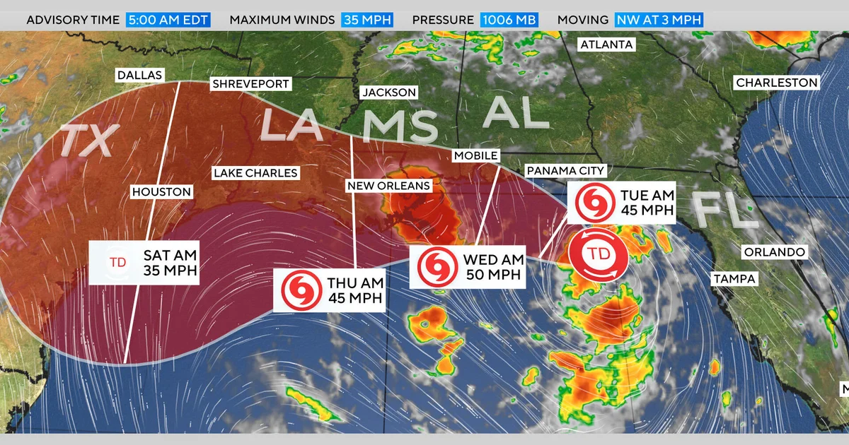
The National Weather Service has released a forecast map detailing Bertha’s anticipated path, which highlights its slow progression along the Gulf Coast. Initially classified as Tropical Depression Two, the storm is expected to gradually strengthen as it travels westward from the Florida Panhandle. By the end of the week, Bertha could reach the northern Gulf Coast, potentially extending its reach toward eastern Texas. While the storm’s speed remains moderate, its direction suggests a prolonged presence in the region, raising concerns about extended rainfall and coastal flooding.
“Bertha is expected to drift slowly west-northwest through the night, then shift toward the west or west-northwest over the next few days,” the National Weather Service explained. “This movement places it in close proximity to the Gulf Coast, increasing the risk of severe weather impacts.” The forecast indicates that the storm may linger near the coast, with its path likely to be influenced by sea surface temperatures and atmospheric conditions. This slow movement could lead to prolonged exposure for coastal communities, compounding the effects of heavy rainfall and high winds.
Impact Areas and Warnings
Authorities have issued Tropical Storm Watches and Storm Surge Watches to alert residents of the Gulf Coast. The Tropical Storm Watch covers from the Ochlockonee River in Florida to the Jefferson/Plaquemines Parish boundary in Louisiana, while the Storm Surge Watch spans the Alabama/Florida border down to the Mississippi River’s mouth. These warnings signal the potential for widespread flooding and strong winds, urging communities to prepare for the storm’s arrival. Tropical Storm Bertha forms threatening, with its slow drift along the coast raising the likelihood of sustained rainfall and localized flooding.
Heavy rainfall, potentially reaching 8 inches in some areas, is anticipated from western Florida through the Texas shoreline. This precipitation could lead to flash flooding in low-lying regions and urban centers, particularly in areas with poor drainage systems. Additionally, coastal zones may experience storm surges, with waters expected to rise by up to 4 feet in certain spots. The combination of high winds and rising tides could damage infrastructure, disrupt transportation, and pose risks to marine life.
Weather Conditions and Storm Surge
As Tropical Storm Bertha forms threatening, the National Weather Service is closely monitoring its development against the backdrop of warmer-than-average sea surface temperatures in the Gulf. These conditions often contribute to stronger storm systems, which could see Bertha intensify further as it moves through the warm waters. The storm’s path is also influenced by the presence of a high-pressure system to the north, which may slow its movement and prolong its impact on the Gulf Coast.
Storm surge remains a critical concern, especially for areas like the Mississippi River delta and the Alabama coast. Rising waters could inundate coastal properties, overwhelm drainage systems, and create hazardous conditions for residents. Inland regions are not spared, as heavy rainfall from Bertha forms threatening is forecast to spread across Florida, Georgia, and the southeastern United States. This weather pattern could also lead to widespread power outages and downed trees, emphasizing the need for preparedness in all affected areas.
Historical Context and Regional Preparedness
The formation of Tropical Storm Bertha aligns with the active hurricane season trends observed in recent years. Similar to previous storms, Bertha forms threatening due to the convergence of warm ocean currents and favorable atmospheric conditions. Regional preparedness efforts are underway, with emergency management teams coordinating resources to address potential evacuations, sheltering, and recovery operations. The Gulf Coast’s vulnerability to such systems underscores the importance of early warnings and community resilience.
As the storm approaches, local authorities are advising residents to stay updated with the latest forecast maps and track Bertha’s progress. The National Weather Service provides real-time updates, including detailed trajectory projections and intensity forecasts, which are essential for informed decision-making. While the exact path of Tropical Storm Bertha forms threatening remains under review, its movement along the Gulf Coast highlights the interconnected nature of weather patterns and the ongoing challenges of storm preparedness in the region.